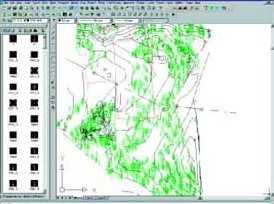
Autodesk Survey �ă�(n��i)��I(y��)�y(c��)����(sh��)��(j��)���Ԅ�(d��ng)���ɈD�Σ�����(qi��ng)�����o�cƥ����Autodesk Survey ��Autodesk Land Desktop 2007�ĔU(ku��)�䑪(y��ng)��ϵ�y(t��ng)����AutoCAD����A(ch��)�Ի��A(ch��)�m�Ϝy(c��)��������Ҏ(gu��)���c��ľ���̴��I(y��)�����c(di��n)��Autodesk Survey�cAutodesk Land Desktop �Y(ji��)������ʹ��(sh��)��(j��)�ɼ����̸���������p�����S����IJ��E���Լ����M(f��i)�ڌW(xu��)��(x��)�����@�(y��ng)��ϵ�y(t��ng)�ϵĕr(sh��)�g�c���X��
����Autodesk Survey �U(ku��)չ��Autodesk Land Desktop �Ĺ����������Ԅ�(d��ng)���ɾ����D���c(di��n),��̖(h��o)������(j��)Ұ�⿱�y(c��)��(sh��)��(j��)ֱ�����ɵ���ģ�͵ĸ��N���������а������Ñ����x�ĈD��������ֱ�����������Ԅ�(d��ng)���Ӝy(c��)���c(di��n)����������Ϣ����݆�����D���������ģ�͵�߅��������O(sh��)Ӌ(j��)�΄�(w��)����I(y��)�y(c��)���T߀���ƶ����¶Ⱦ��y(c��)�O(sh��)�c(di��n)��(sh��)��(j��)���d���y(c��)��?j��)x���У���Ř����Ü�(zh��n)����
Get more field data in less time using Autodesk® Survey 2007 for seamless upload into Autodesk® Land Desktop 2007. Autodesk Survey 2007 supports a wide range of industry-standard data collectors, survey instruments, and global positioning system (GPS) receivers that let you quickly and accurately capture points and survey figures.


